Delivery drivers hate missed deliveries as that means they’ll have to come back the next day, and one of the biggest causes of missed deliveries is not finding a named address such as farms and cottages.
Named addresses are difficult to find because popular maps systems like Google Maps and Apple Maps rarely list them accurately.
What is a named address in the UK?
A named address in the UK is an official property whose street address has been changed to a name such as Rose Cottage, The Old Barn, or Willow Farm. Such properties have an underlying street address, but their published address is the property name and its postcode. Think of it like a private vehicle registration number.
Professional delivery drivers frequently struggle with these locations because standard consumer maps such as Google maps do not list these addresses in full. They often only show the postcode.
But postcodes are accurate, aren’t they?
Unfortunately not accurate enough for a delivery driver! The postcode in a conventional map often points to the general postcode area rather than the individual property boundary and that can be a few meters to 100s of meter away, it’s a lottery. To the resident, the location is obvious; they know the lane, the gate, the bend, and the small sign on the wall with their property name on it. To a courier on a tight schedule, it is a time-wasting guessing game driving slowly in the dark looking for small a wooden post with a property name on it.
Why do Google Maps pins fail in rural UK postcodes?
The core issue is a simple technical limitation: a postcode is not a front door.
Many farms, barn conversions, and named cottages share a single postcode with multiple surrounding properties. In rural sectors, a single postcode can cover a geographic area spanning several square miles.
When navigating to these areas, standard consumer mapping tools default to either:
- Dropping the pin in the exact geographic center of the postcode area.
- Directing the driver to the nearest paved road, which may not connect to the property.
- Routing to an incorrect or historical boundary entrance.
For professional courier work, being close could still mean being lost. The parcel does not just need the postcode; it requires the exact delivery point.
Numbered Houses vs. Named Properties: How do they compare?
To understand why delivery schedules slow down in rural and semi-rural areas, it helps to look at how data to compare the difficulty in locating each address type:
| Address Type | Navigation Structure | Signage Visibility | Map Pin Accuracy |
| Numbered House | Sequential and predictable (e.g., 42 High Street) | Usually visible on the structure or gate | Medium accuracy via standard postal data. An experienced driver will can track the numbers down the street. 2 then 4 will mean 6 is further down |
| Named Cottage | Non-sequential; scattered along lanes | Often obscured by hedges, walls, or vegetation | Low accuracy; the properties are not named in any logical order. willow house could be next to number 16 or further up the road, the driver will have to guess that. |
| Rural Farm | Large acreage with multiple detached units | Set back from the main road and rarely well lit | Very low; fails to identify the specific drop-off point. Farms are often large estates with many buildings dotted around |
A cottage sign might be hidden behind a mature hedge, a farm entrance might be set back half a mile from the main road, and a barn conversion might sit entirely behind a separate building. The sat-nav announces arrival, but the driver is left to guess which gate, track, or private entrance is the correct one.
So, why is navigating to farms uniquely challenging?
Farm addresses present a distinct logistical hurdle because they often consist of large parcels of land with multiple operational zones. The actual delivery point could be any of the following:
- The primary farmhouse
- The commercial yard
- A farm office or workshop
- A diversified, converted commercial unit on the same land
Standard navigation software often lacks the granularity to distinguish between these points. This forces drivers to slow down, double-check paperwork, turn into incorrect tracks, reverse out safely, and try the next entrance. The driver is not the problem; the underlying postcode data is simply not precise enough for commercial delivery standards.
So how do pro drivers find named houses without numbers?
- Experienced couriers combine local knowledge with specialized address finding tools like Delm8 route planner to locate these trickier addresses.
- They pay attention to textual clues in the address, for example words like Barn, Lodge, Manor, Stables, Yard, or Mill as they help identify the type of property layout to expect.
However, local knowledge can only scale so far. The most efficient professional drivers rely on dedicated spatial tools to protect their delivery windows.
Best route planner for UK delivery drivers handling farms – Delm8 route planner
The Delm8 route planner app is purpose-built to solve the named address problem. It operates alongside standard sat-nav applications to pinpoint highly specific geographic locations, from remote rural farms to newly developed urban flat complexes.
How Delm8 resolves address ambiguity:
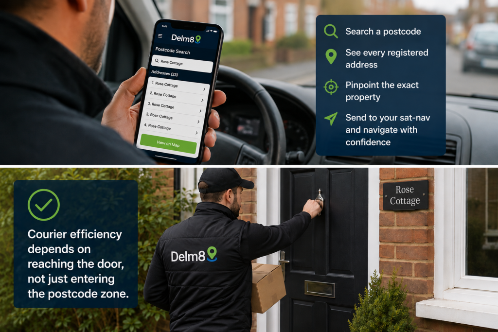
- Postcode Interrogation: Delm8 allows drivers to search a postcode and view a complete list of every registered address contained within that specific boundary.
- Geographic Pinpointing: Drivers can select the exact named property from the list to see its precise location before opening their preferred navigation app, such as Google Maps, Waze, or Apple Maps.
- Preserving Efficiency: The goal is not to replace the primary navigation map, but to prevent the sat-nav from routing the vehicle to an incorrect location at the final approach.
- Delm8 leads Sat-nav follows:Delm8 pinpoints the named address and then informs your sat-nav. The sat-nav then takes over the turn-by-turn navigation. That’s the winning combination.
To conclude, always remember: courier efficiency depends on reaching the door, not just entering the postcode zone.
Estimated reading time: 5 minutes